Hiking in the mountains is a national pastime in Bulgaria, where a landscape of glacial valleys and crystal-clear alpine lakes is complemented by a climate blessed with a moderating Mediterranean influence in the summer months from June to August.
In winter (December to February), those same peaks are covered in snow, but snowshoeing is a thrilling way to explore these rugged mountains on foot (and have an adventure of a lifetime in the process).
For long-distance walkers, the trans-European E3, E4 and E8 hiking trails weave through the Bulgarian countryside. Once you’ve finished trekking, there are mineral spas where you can soak tired muscles in towns such as Hisar in the southern foothills of the Sredna Gora mountain range, and Sapareva Banya in the Rila Mountains – both were important wellness centers as far back as the Roman era.
Whether you fancy a day walk close to the capital, Sofia, or a multi-day hike through the Stara Planina mountain range, Bulgaria is the perfect destination for outdoors enthusiasts at all levels of fitness. Here are a few of the best hikes to add to your Bulgaria itinerary.
1. Seven Rila Lakes (Rila National Park)
Best for a day trip
Distance: 10km (6.2 miles)
Estimated time to complete: 4 hours
Advertisement
Level of difficulty: Easy
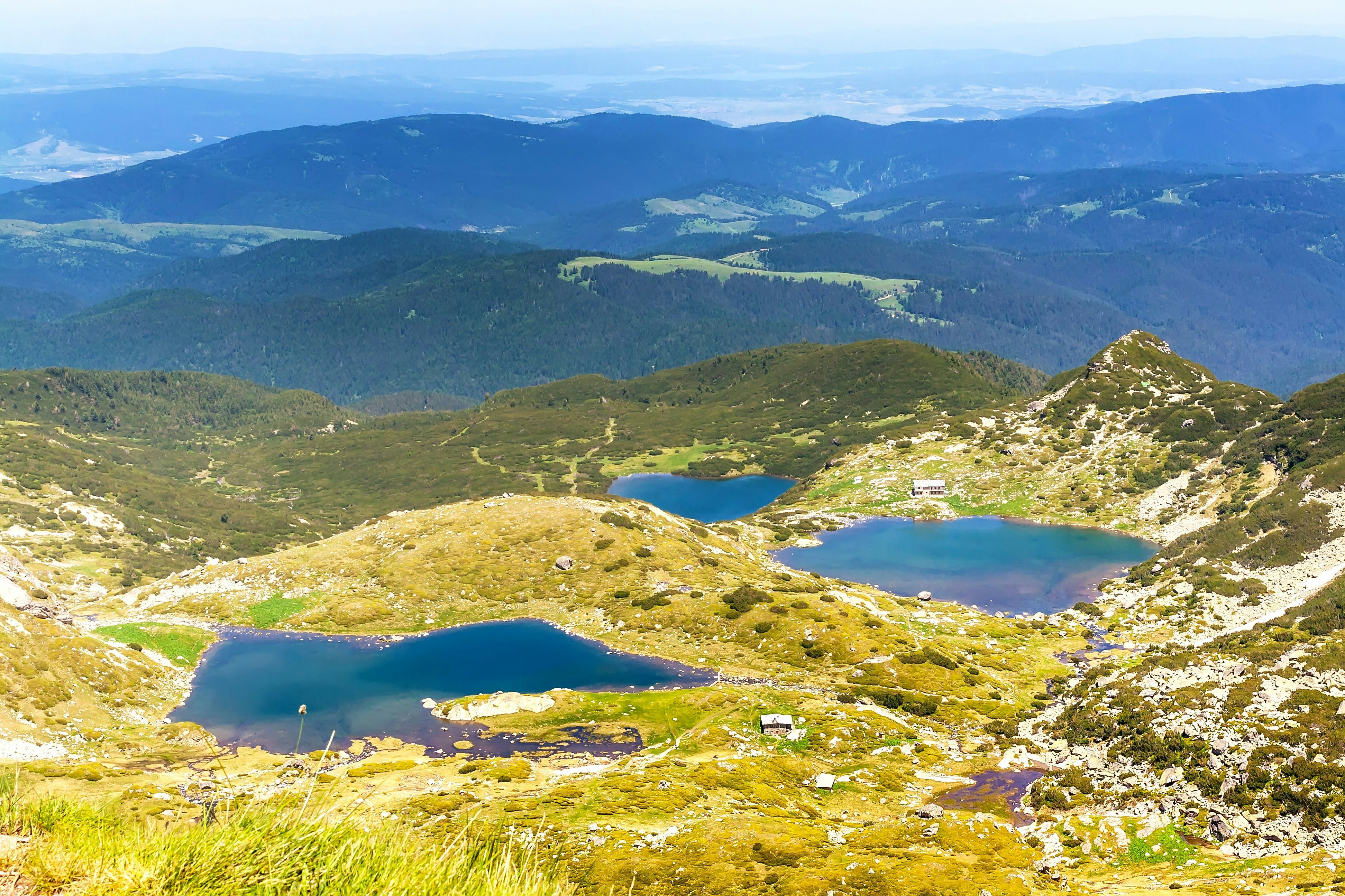
Rila National Park, Bulgaria’s largest protected area, covers swathes of peaks, forests and high pastures, as well as glinting glacial lakes. In fact, the word “Rila” – possibly derived from ancient Thracian – means “Mountains of Water,” a nod to the area’s turquoise lakes.
The park is just 90km (56 miles) from Sofia, so you can hike between these jewel-like lakes on a long day-trip from the capital. But it’s best to stay overnight to see more of what this stunning region has to offer, like historic Rila Monastery and the Goritsa waterfall.
The day-long Seven Rile Lakes walk begins with a ride on the Pionerska chairlift from the winter ski resort of Panichishte in the northwest of the park. You’ll be transported over towering trees to an elevation of 2100m (6890ft), where you’re immediately surrounded by alpine meadows circled by granite rocks. Here, the first of Rila’s seven lakes comes into view.
Over the next 10km (6.2 miles), you’ll follow a well-marked path past six more shimmering lakes of different shapes and sizes. Admire the epic views, and look out for wildflowers among the granite outcrops, and golden eagles and peregrine falcons above. There are shorter routes back if you’re struggling on the outbound leg.
At the end of the hike, reward yourself for all that exertion with an afternoon (or a whole day if time allows) of soaking in the geothermal waters of Sapareva Banya, where you’ll also find steam rooms, Jacuzzis and massages that are perfect for relaxing tired muscles.
Planning tip: Arrive at the chairlift early to avoid having to queue – especially on weekends!

2. Malyovitsa Peak (Rila National Park)
Best for avoiding the crowds
Distance: 36km (22 miles)
Estimated time to complete: 2 days
Level of difficulty: Moderate
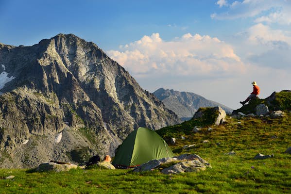
For a wilder Rila National Park experience, you’ll need to climb a little higher into the mountains than the day trippers on the popular Seven Rila Lakes route. In the crags above is a less-trodden route – a two-day Rila mountains traverse, taking in one of the highest summits and ending with a spiritual and artistic flourish at the 10th-century Rila Monastery.
From the starting point in the meadows beside the Malyovitsa Central Mountain School, about 25km (15.5 miles) southwest of Samokov, you’ll stroll through an area of forest, watching crossbills snaffling seeds from pine cones. Beyond, a rocky track traces the valley floor through scrubby heathland, climbing toward a forbidding rock wall above which alpine choughs and buzzards wheel.
At the head of this valley is a memorial cairn bearing plaques and climbing equipment, commemorating Bulgarian climbers who lost their lives in these mountains. The trail steepens rapidly, taking hikers over boulders green with lichen and ferns poking out of cracks, on the ascent to Elenini Ezero (Deer Lake).
Beyond the lake, the trail rises again to the grey ridge ending at Malyovitsa Peak. This is not quite the “roof of Bulgaria” – that accolade goes to nearby 2925m (9596ft) Musala – but Malyovitsa reaches a respectable 2729m (8953ft). Further south along a heavily wooded valley is Rila Monastery, your ultimate destination at the end of the trail.
Planning tip: There are wild cats and capercaillie here, as well as bears and wolves, although you’ll be fortunate to spot them. Make sure you’re aware of the local mountain safety advice before you depart, just in case.

3. Rayskoto Praskalo and Botev Peak (Central Balkan National Park)
Best waterfall view
Distance: 24km (15 miles)
Estimated time to complete: 1–2 days
Level of difficulty: Moderate to challenging
In the heart of Bulgaria, Central Balkan National Park is a paradise for hikers seeking unspoiled nature, dramatic mountain scenery, and rich biodiversity. Covering more than 700 sq km (270 sq miles), the park takes in the highest parts of the Balkan Mountains (Stara Planina), with soaring peaks and deep forested valleys.
Advertisement
One of the most popular hiking routes here is the trail to 2376m (7795ft) Botev Peak. The route begins from Kalofer, a small town at the southern foot of the range. From here, you’ll follow the trail through the Panitsite area to Rai Hut (Hizha Rai), around 11km (6.8 miles) from the start point – a good place to stop for the night.
It’s not far from the hut to the spectacular Rayskoto Praskalo waterfall, the highest waterfall in the Balkans, which drops 125m (410ft). The best way to trek this route is to stay overnight at Rai Hut and summit Botek Peak the next day, allowing plenty of time to climb, soak up the views and return safely before dark.
However, experienced walkers can push on to the summit of Botek Peak in one day – it’s only another 4km (2.5 miles) but the climb involves a 900m (2953ft) ascent. In total, the full summit hike from Kalofer to Botek and back is around 24km (15 miles) – around nine hours of walking.
Planning tip: The terrain is steep, especially near the top, and weather can change rapidly, so pack proper mountain hiking gear, and bring layers to protect against the cold at the top.

4. Vihren Peak (Pirin National Park)
Best for a sense of achievement
Distance: 10km (6.2 miles)
Estimated time to complete: 1 day
Level of difficulty: Moderate to challenging
The crown jewel of the Pirin Mountains, Vihren Peak is Bulgaria’s second-highest mountain at 2914m (9560ft), but it’s surprisingly accessible – providing you don’t suffer from vertigo!
The walk begins at Vihren Hut, set at 1950m (6400ft) above sea level. A regular bus links the resort town of Bansko with Vihren Hut, but hikers looking for more of a challenge can hike from Bansko before ascending above the treeline.
As you climb higher, the views become increasingly spectacular, with sweeping panoramas of UNESCO-listed Pirin National Park and its dramatic ridges, sparkling glacial lakes and distant mountain ranges.
From Vihren Hut, it’s an 8km (5-mile) uphill climb to the top of Vihren. You’ll gain nearly 1000m (3280ft) in elevation over just a few hours of tramping uphill. The final stretch is steep and exposed, requiring a good footing and a head for heights, especially in windy conditions. For the effort, you’ll be rewarded with incredible views toward Rila and beyond.
Detour: On your return, soak in a hot mineral spring in a spa in one of the nearby villages – there are several spas at various price points in Bankso and Dobrinishte.

5. Koncheto Ridge (Pirin National Park)
Best for adrenaline and bragging rights
Distance: 12km (7.5 miles)
Estimated time to complete: 1 day
Level of difficulty: Challenging
One of the most thrilling routes in Bulgaria is the hike – or rather, scramble – between Vihren Peak and Kutelo Peak. At 2908m (9540ft), Kutelo peak is the second-highest peak in the Pirin Mountains.
This is one for experienced and confident hikers only; wear appropriate hiking gear, and seek local advice about trail and weather conditions, including incoming rain or fog.
The dramatic, 12km-long (7.5-mile) trail traverses a narrow limestone ridge that plunges steeply on both sides. In places, the path is just a meter wide. There are chains bolted into the rock to assist hikers along the most vertiginous sections, but it can still be an unnerving experience.
The name “Koncheto” (meaning “Little Horse”) refers to the way some hikers straddle the ridge like a horse rider for balance. The adrenaline rush is powerful, but so are the views — the surrounding peaks, glacial cirques and deep valleys create an uplifting alpine spectacle.
Hiking along both the Mt Vihren and Koncheto Ridge trails in one day is possible, but you will need to be very fit and start early.
Detour: It’s possible to hike to Kutelo Peak from alternative starting points such as the Yavorov Hut, turning this into a one-way walk, exiting at Vihren Hut, where you can catch the bus back to Bansko.

6. Five Mountains Trail
Best long-distance hike
Distance: 260km (161 miles)
Estimated time to complete: 13 days
Level of difficulty: Moderate to challenging
The Five Mountains Trail traverses (you guessed it) five mountains in Bulgaria – Vitosha, Verila, Rila, Pirin and Slavyanka. The route takes you into limestone mountains, past waterfalls and caves, and through pristine coniferous forests.
The trail is part of the E4 European long-distance path, a spectacular hiking route stretching over 10,000km (6213 miles) from Portugal to Greece. It’s a reminder that Bulgaria has long been an important junction on European trade routes, occupied by Macedonians, Romans, Bulgars and the Ottoman Empire over the centuries.
The way is marked with red signposts, and with some planning, you can pre-book mountain refuges or huts to sleep in. These are well spaced along each of the 13 segments of the hike. You should still carry a tent in case a hut is full or you don’t make the distance of the day. Some of the hike traverses very rocky paths, particularly in the Rila and Pirin Mountains, which is why it’s recommended for experienced, well-equipped hikers only.
As this hike takes you to remote mountain locations, you’ll also need to carry food supplies and plan where you can top up supplies en route. It’s worth investing in a trail-specific guidebook for this one!
The classic route takes you up Vihren Peak and along the Koncheto Ridge, but further south, the going gets gentler in the Rhodope Mountains, where the trail winds through forests, meadows, and remote villages where you can experience traditional Bulgarian life and admire Ottoman-era architecture.
7. Vitosha Nature Park
Best for snowshoeing
Distance: 12km return (7.5 miles)
Estimated time to complete: 1 day
Level of difficulty: Easy to moderate
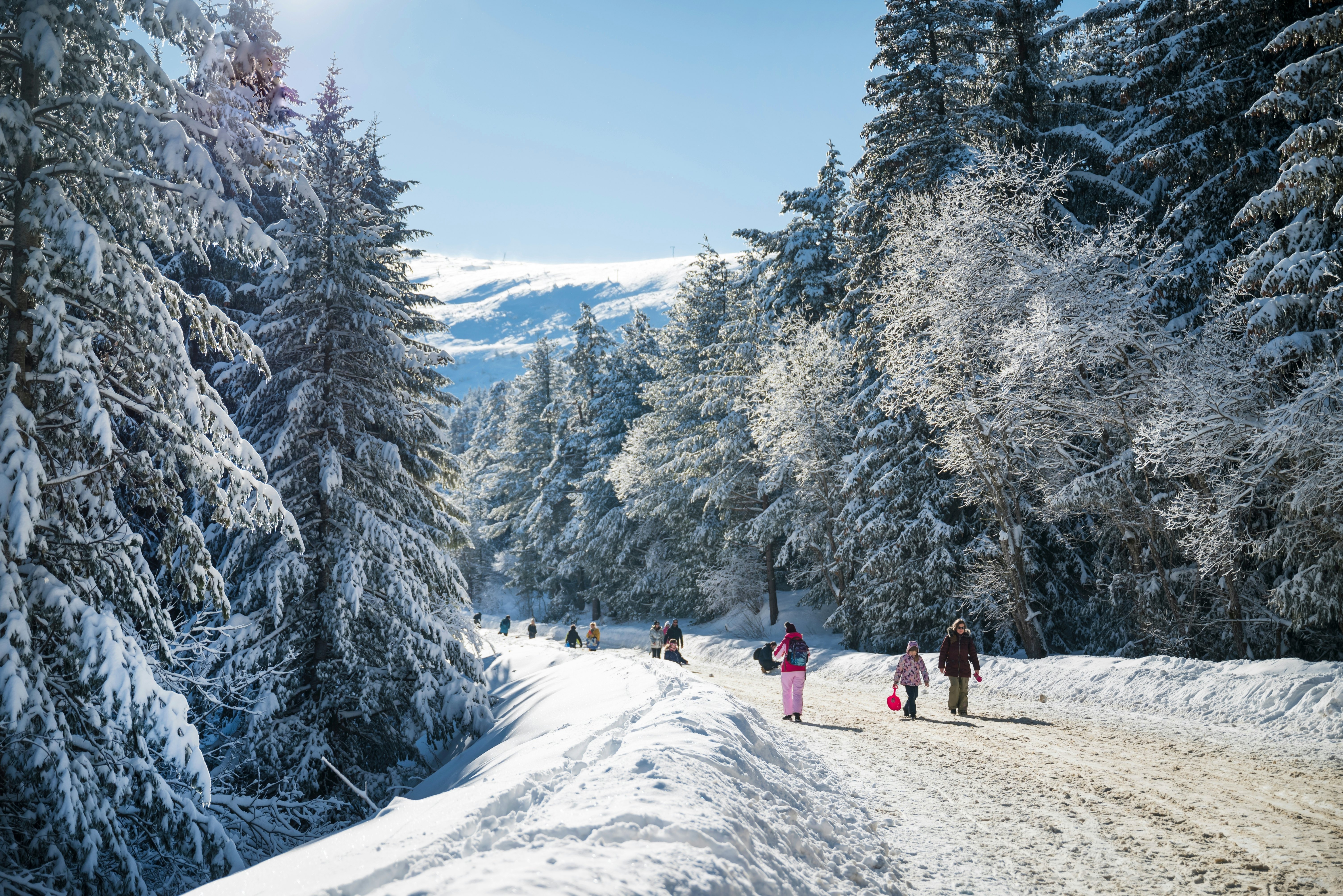
On the outskirts of Sofia, Vitosha Nature Park offers a peaceful escape from the capital, but with a difference if you come in winter. From December to March, snow blankets the mountains, and the park is transformed into a serene wonderland perfect for a snowshoeing adventure.
Vitosha is the oldest nature park in Bulgaria, and it’s highly recommended for its well-marked hiking and snowshoeing trails, and its mix of alpine meadows and forest landscapes. One of the most popular routes is from Aleko Hut – set at 1810m (5940ft) – to the top of 2290m (7515ft) Cherni Vrah, the highest peak in Vitosha. You can reach Aleko Hut by public transport and hire snowshoes here.
The route begins with a gradual ascent through frost-covered pine forests, then opens onto a high alpine plateau. At the top, you’ll be rewarded with panoramic views of the Sofia Valley and the Rila Mountains. It’s a moderately challenging walk at around 6km (3.7 miles) each way, and it can take up to 3 hours to reach the summit in summer; plan on more time in winter to be safe.
No technical skills or experience are required for snowshoeing at Vitosha; all you need is waterproof boots, warm layered clothing, and a pair of snowshoes. An alternative winter walk is the track to the Boyana waterfall, starting at Boyana Church. This route takes you through quiet beech forests to a beautiful waterfall that is partially frozen in winter.
Planning tip: Organized snowshoeing tours are available, and recommended if you’re unfamiliar with winter hiking or want a more in-depth experience of the mountains. Guides know where to be more cautious – for example, where icy rocks make the trails more treacherous — which is particularly useful on the Boyana waterfall trail.

Top tips for hiking in Bulgaria
The following tips will help you plan a hiking trip to Bulgaria.
-
Some of Bulgaria’s best trails pass through Rila National Park, Pirin National Park and Central Balkan National Park – be aware that the flora, fauna and environment are protected, and heed environmental rules. Some trails also pass through Bulgaria’s system of “nature parks,” which also have unique, managed ecosystems.
-
June to October is the best time to hike for snow-free paths, but winter walks and mountain ascents are also possible in Bulgaria, so long as you have the right gear.
-
Waterproofs, warm layers and sturdy hiking boots are essential for walking in Bulgaria, even in summer. If you’re hiking in the mountains, it can be significantly colder at altitude, especially if you’ve worked up a sweat.
-
Bring a sleeping bag for multi-day hikes; if you’ve pre-booked a refuge where blankets are provided, you may be able to get by with a sheet or sleeping bag liner. Always check ahead to see what facilities are on offer.
-
While major trails are well-marked, carrying a detailed map and compass is highly recommended. Don’t rely on only using your phone to navigate in case the battery runs out.
This article was adapted from Lonely Planet’s Romania & Bulgaria guidebook, published in August 2024.